Atnaujinkite slapukų nuostatas

Geophysical Phenomena and the Alexandrian Littoral [Kietas viršelis]

  • Formatas: Hardback, 146 pages, aukštis x plotis x storis: 245x175x20 mm, weight: 610 g, 51 figures, 2 tables (51 pages in colour); 2 Tables, color; 51 Figures
  • Išleidimo metai: 05-Aug-2019
  • Leidėjas: Archaeopress
  • ISBN-10: 1789692342
  • ISBN-13: 9781789692341
Kitos knygos pagal šią temą:
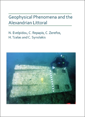
Alexandria is located on the Mediterranean coast of Egypt, bordered by Egypt&;s Western Desert and the fertile Nile Delta. For many centuries, Alexandria was the major port city in the Eastern Mediterranean and it has been repeatedly struck by natural disasters, such as earthquakes, tsunamis and land subsidence, in its ~2400-year history. This book focuses on the geomorphological and archaeological evidence on the coastal zone of Alexandria, attempting to provide a comprehensive review of its evolution, taking into consideration long-term and short-term factors.

The book provides an extensive background on the geomorphology and recent geoarchaeological history of Alexandria, discussing historical maps and natural disasters. In the coastal area of Alexandria there is numerous archaeological evidence, such as burial sites, quarry activities and ancient building remnants, as well as geomorphological features, all revealing a complex evolution of the coastal zone. New evidence, such as fish tanks and ship wrecks in order to discuss the Late Holocene evolution of the coastal zone. Detailed illustrations and maps accompany the book chapters providing the reader the opportunity to gain an extensive view of Alexandria&;s features.

This book presents the geomorphology and recent geoarchaeological history of Alexandria which has been repeatedly struck by natural disasters. The Coastal area offers archaeological evidence (burial sites, quarry activities and ancient building remnants), as well as geomorphological features, all revealing a complex evolution of the coastal zone.
List of figures and tables
iii
Acknowledgements v
Preface vii
1 Introduction
1(13)
1.1 Location and physical geography
1(4)
1.2 Geological characteristics
5(5)
1.3 Geomorphology
10(4)
2 Subsidence regime
14(6)
2.1 Bathymetry
14(2)
2.2 Submerged ancient structures
16(4)
3 Evidence of offshore subsidence in Alexandria
20(9)
4 Palaeogeography
29(4)
5 Historical maps
33(29)
Veduta d'Alessandria Codice Urbinate 277 [ 1472]
34(2)
View of Alexandria from the Portolano of Piri Reis [ 1513]
36(2)
Vray portraict de la Ville d'Alexandrie en Egypte [ 1547]
38(2)
Plan M.P.nl-XLIX-43 of Alexandria from the Archivos General de Simancas [ 1605]
40(2)
Alexandria, Vetustissimwn Aegypti Emporium [ 1619]
42(1)
View of Alexandria by Vassili Barkij [ 1730]
43(3)
Description de la ville dAlexandrie, telle quelle etoit du terms de Strabon, par M. Bonamy [ l73l]
46(2)
Carte et Plan du Port Neuf dAlexandrie by Capt. Frederick Lewis Norden [ 1738] and Carte particuliere de la Vielle et de la nouvelle Alexandrie et de ses Ports [ 1738]
48(1)
Konstantin of Kiev 'θεα tau;oν.λιμενoσ τησ Aλεξανδρειασ [ 1795]
49(1)
Konstantin of Kiev 'Xαρτατησ 'Aλεξανδριασκαιτωνδνωαντησλιμενων [ 1795]
49(4)
Carte generale des cotes, rades, ports, ville et environs dAlexandrie dressed par M. Gratien le Pere [ 1798]
53(1)
Plan of the city harbours and environs of Alexandria
54(2)
Captain Smyth
Plan dAlexandrie par Mahmoud Bey el Falaki [ 1866]
56(6)
6 Historical references
62(4)
7 The decline of Alexandria and physical disaster
66(5)
8 Modelling tsunami vulnerability
71(7)
8.1 Simulating possible tsunamis in Alexandria
72(1)
8.2 Scenario megathrust tsunami sources
73(1)
8.3 Tsunami simulation results
74(1)
8.4 Tsunami impacts at Alexandria
75(3)
9 Coastal zone
78(11)
9.1 Silsileh
78(1)
9.2 Chatby
78(4)
9.3 Ibrahimia
82(1)
9.4 Sporting Beach
83(2)
9.5 Moustafa Kamel
85(1)
9.6 Gleemenopoulos Beach
85(1)
9.7 SidiBishr
85(1)
9.8 Miami Island -- Gezira Gabal el Khour (Gabr el Khour)
86(1)
9.9 Montazah
86(1)
9.10 Maamourah
87(1)
9.11 Abou Kir
87(1)
9.12 Nelson's Island (Abou Kir Island)
88(1)
10 Fish tanks
89
10.1 Fish tanks in Alexandria
90(2)
10.2 Fish tank findings
92(20)
10.2.1 Montazah fish tanks
93(5)
10.2.2 Abou Kir fish tank
98(6)
10.2.3 Miami Island fish tank
104(8)
10.3 Main sea level indicators
112(3)
10.3.1 Protective moles
112(1)
10.3.2 Upper walkway (upper crepidine)
113(1)
10.3.3 Lower crepidines
113(1)
10.3.4 Closing gates (cataractae)
113(1)
10.3.5 Channels
114(1)
10.4 Sea level modelling
115(1)
10.5 Relative sea level changes and Alexandria's fish tanks
115(3)
References
118
Niki Evelpidou is a Professor of Geomorphology and Geoinformatics at the National and Kapodistrian University of Athens, Faculty of Geology and Geoenvironment, and Faculty Affiliate of the Department of Geology and Environmental Geosciences of the College of Charleston, USA. Prof. Evelpidou is actively involved in the research fields of geomorphology, coastal geomorphology, sea level changes, palaeogeography, geology, spatial technologies, study and modelling of natural hazards, while emphasizing on the use of new technologies and innovation.


Christos Repapis was Director of the Research Centre of Atmospheric Physics and Climatology of the Academy of Athens (1985-2005) and has remained as Research Associate of the Centre since his retirement.


Christos Zerefos heads the Research Centre for Atmospheric Physics and Climatology, Academy of Athens and is president-elect of the General Assembly of the Hellenic Foundation for Research and Innovation. Other roles academic posts include Professor of Atmospheric and Environmental Physics (Universities of Athens and Thessaloniki), Visiting Professor (Universities of Minnesota and Boston) and Samarbeidspartnere (University of Oslo).


Harry Tzalas has conducted a range of innovative experimental archaeological studies relating to ancient sea vessels. In 1997 he formed the Hellenic Institute of Ancient and Mediaeval Alexandrian Studies and obtained a concession from the Egyptian Authorities for an underwater survey of 14 kilometers of the eastern littoral of Alexandria; 28 campaigns were successfully conducted.


Costas Synolakis is Professor of Civil Engineering at the University of Southern California and a a member of the Academy of Athens holding the Chair of Earth Sciences. His research studies the impact of natural hazards, and particularly tsunamis and extreme flooding events on beaches. He has  participated or led 30 scientific expeditions in 21 countries, practically in all of the worlds oceans and seas.