Free cookie consent management tool by
TermsFeed
Perkamiausios knygos
New York Times Bestsellers
Publishers Weekly Bestsellers
UK TOP 50
E-book Bestsellers
E-platformos
Taylor and Francis eBooks
Oxford University Press e-products
Ebook Central elektroninių knygų platforma
Springer eBooks
Wiley Digital Books
daugiau
Klientų aptarnavimas: +370 652 87781
Pagalba
|
Naujas vartotojas
|
Prisijungti
LIT
Eesti keeles
In English
Latviešu valoda
Knygos anglų kalba
Knygos anglų kalba
Knygos vokiečių kalba
Knygos rusų kalba
Estiškos knygos
E-knygos anglų kalba
Kalbų mokymo literatūra
Muzikos knygos
Leidyklų e-knygos
Išplėsta paieška
Knygos »
0 vnt.
0,00 €
El. knygos »
0 vnt.
0,00 €
E-kuponai »
0 vnt.
0,00 €
ELT knygos »
0 vnt.
0,00 €
Seminars »
0 vnt.
0,00 €
Giftbooks »
0 vnt.
0,00 €
Krepšelis tuščias
Pirkinių krepšelis
0
Pageidavimų sąrašas
Prisijungti
Nauja paskyra
Jūsų paskyra
Keisti duomenis
Pakeisti slaptažodį
Dovanų kuponai*
Pageidavimų sąrašas
Asmeniniai nustatymai
Pristatytos knygos
Atvyksta
Užsakymų sąrašas
Sąskaitos
Atšaukti užsakymai
Įsigyti E-kuponai
Jūsų paskyra
Kategorijos
Knygos anglų kalba
Arts and Architecture
(1097168)
Arts and Architecture
Architecture
(129625)
Art forms
(112087)
Art treatments & subjects
(145752)
Dance & other performing arts
(22362)
Film, TV & radio
(99645)
History of art / art & design styles
(143673)
Industrial / commercial art & design
(85014)
Music
(308239)
Photography & photographs
(123033)
The arts: general issues
(104497)
Theatre studies
(11283)
Biography & True Stories
(840749)
Biography & True Stories
Biography: general
(655264)
Diaries, letters & journals
(46060)
Memoirs
(144406)
True stories
(56417)
Children's, young adult & educational
(2683363)
Children's, young adult & educational
Children's & young adult fiction & true stories
(1220578)
Children's & young adult poetry, anthologies, annuals
(39194)
Children's & young adult reference material
(18321)
Children's & young adult: general non-fiction
(715212)
Children's stationery & miscellaneous items
(7304)
Educational material
(763525)
Personal & social issues
(290260)
Picture books, activity books & early learning material
(411790)
Computing & information technology
(412279)
Computing & information technology
Business applications
(44422)
Computer certification
(5358)
Computer hardware
(25516)
Computer networking & communications
(36451)
Computer programming / software development
(87959)
Computer science
(122580)
Computer security
(19526)
Computing: general
(68493)
Databases
(31727)
Digital lifestyle
(44646)
Graphical & digital media applications
(33986)
Operating systems
(20130)
Earth sciences, geography, environment, planning
(290772)
Earth sciences, geography, environment, planning
Earth sciences
(76676)
Geography
(95728)
Regional & area planning
(18830)
The environment
(130848)
Economics, finance, business & management
(1276443)
Economics, finance, business & management
Business & management
(723903)
Economics
(297399)
Finance & accounting
(201191)
Industry & industrial studies
(202769)
English language teaching (ELT)
(59348)
English language teaching (ELT)
ELT background & reference material
(5393)
ELT: English for specific purposes
(2211)
ELT: learning material & coursework
(53624)
Fiction & related items
(3790729)
Fiction & related items
Adventure
(316778)
Classic fiction (pre c 1945)
(307125)
Crime & mystery
(401868)
Erotic fiction
(78878)
Fantasy
(319709)
Fiction-related items
(4437)
Fiction: special features
(177406)
Graphic novels
(144055)
Historical fiction
(180226)
Horror & ghost stories
(130593)
Modern & contemporary fiction (post c 1945)
(1532516)
Myth & legend told as fiction
(41928)
Religious & spiritual fiction
(92637)
Romance
(582502)
Sagas
(33480)
Science fiction
(234532)
Thriller / suspense
(335419)
Health & personal development
(1432720)
Health & personal development
Family & health
(583440)
Mind, Body, Spirit
(354168)
Self-help & personal development
(648989)
Humanities
(3989567)
Humanities
Archaeology
(77575)
History
(2471550)
Philosophy
(322700)
Religion & beliefs
(1335502)
Language
(584424)
Language
Language teaching & learning (other than ELT)
(241014)
Language: reference & general
(158875)
linguistics
(232969)
Law
(677737)
Law
International law
(53077)
Jurisprudence & general issues
(313980)
Law: study & revision guides
(4543)
Laws of Specific jurisdictions
(361137)
Lifestyle, sport & leisure
(2375738)
Lifestyle, sport & leisure
Antiques & collectables
(45796)
Cookery / food & drink etc
(299133)
Gardening
(51697)
Handicrafts, decorative arts & crafts
(212383)
Hobbies, quizzes & games
(138897)
Home & house maintenance
(37481)
Humour
(120402)
Lifetyle & personal style guides
(41450)
Local interest, family history & nostalgia
(109852)
Miscellaneous items
(445019)
Sports & outdoor recreation
(276399)
The natural world, country life & pets
(255355)
Transport: general interest
(86878)
Travel & holiday
(450098)
Literature & literary studies
(2690528)
Literature & literary studies
Anthologies (non-poetry)
(1674049)
Literature: history & criticism
(434471)
Plays, playscripts
(130603)
Poetry
(482185)
Prose: non-fiction
(71278)
Mathematics & science
(837986)
Mathematics & science
Astronomy, space & time
(34508)
Biology, life sciences
(266990)
Chemistry
(104866)
Mathematics
(213350)
Physics
(132090)
Science: general issues
(160694)
Medicine
(785765)
Medicine
Clinical & internal medicine
(217671)
Complementary medicine
(15406)
Medical study & revision guides & reference material
(16425)
Medicine: general issues
(309539)
Nursing & ancillary services
(93280)
Other branches of medicine
(218161)
Pre-clinical medicine: basic sciences
(50737)
Surgery
(38438)
Veterinary medicine
(14048)
Reference, information & interdisciplinary subjects
(589829)
Reference, information & interdisciplinary subjects
Encyclopaedias & reference works
(404314)
Interdisciplinary studies
(102990)
Library & information sciences
(26557)
Museums & museology
(7897)
Research & information: general
(106205)
Society & social sciences
(2748101)
Society & social sciences
Education
(798878)
Politics & government
(617160)
Psychology
(284449)
Social services & welfare, criminology
(145259)
Society & culture: general
(870804)
Sociology & anthropology
(291869)
Warfare & defence
(112538)
Technology, engineering, agriculture
(657232)
Technology, engineering, agriculture
Agriculture & farming
(78482)
Biochemical engineering
(21230)
Civil engineering, surveying & building
(71833)
Electronics & communications engineering
(92641)
Energy technology & engineering
(56335)
Environmental science, engineering & technology
(45679)
Industrial chemistry & manufacturing technologies
(70482)
Mechanical engineering & materials
(100449)
Other technologies & applied sciences
(58684)
Technology: general issues
(139074)
Transport technology & trades
(46967)
Paieška potemėse
Knygos
Knygos anglų kalba
UK TOP 50
New York Times Bestsellers
Publishers Weekly Bestsellers
Turime sandėlyje (1459)
Arts and Architecture (1097168)
Biography & True Stories (840749)
Children's, young adult & educational (2683363)
Computing & information technology (412279)
Earth sciences, geography, environment, planning (290772)
Economics, finance, business & management (1276443)
English language teaching (ELT) (59348)
Fiction & related items (3790729)
Health & personal development (1432720)
Humanities (3989567)
Rodyti visus »
Knygos vokiečių kalba
Belletristik (441876)
Geisteswissenschaften, Kunst & Musik (582897)
Kinder- & Jugendliteratur (108481)
Mathematik, Naturwissenschaft & Technik (570088)
Reise (186972)
Sachbuch / Ratgeber (238873)
Schule & Lernen (68195)
Sozialwissenschaften, Recht & Wirtschaft (568569)
Rodyti visus »
Knygos rusų kalba
Аудиокниги на CD (4)
Бизнес (8878)
Детская литература (45723)
Дом, семья, хобби, спорт (10076)
Книги на иностранных языках (1061)
Компьютеры и Интернет (3410)
Культура, искусство, публицистика, музыка (10416)
Наука, техника, медицина (55034)
Религия, оккультизм, эзотерика, астрология (9987)
Специальные издания (1083)
Rodyti visus »
Estiškos knygos
E-knygos
E-knygos anglų kalba
E-book Bestsellers
Arts and Architecture (135325)
Biography & True Stories (138746)
Children's, young adult & educational (215380)
Computing & information technology (142768)
Earth sciences, geography, environment, planning (108476)
Economics, finance, business & management (313007)
English language teaching (ELT) (6234)
Rodyti visus »
Leidyklų e-knygos
Arts and Architecture (12303)
Biography & True Stories (1597)
Children's, young adult & educational (2332)
Computing & information technology (10361)
Earth sciences, geography, environment, planning (15390)
Economics, finance, business & management (34819)
English language teaching (ELT) (592)
Fiction & related items (221)
Health & personal development (1481)
Humanities (40882)
Rodyti visus »
Muzikos knygos
Muzikos knygos
Paskutinės 60 dienų
Paskutinės 180 dienų
Paskutinės 365 dienų
Neišleistos
Sheet Music & Books
(419500)
Rodyti visus »
Žanrai
Klasikinė
Sacred
Pop & Rock
TV-Film-Musical-Show
Mokymas
Contemporary Music
Method
Džiazas
Hymns & Chorals
Concert Piece
Studies & Exercises
Formatas
Natos
Knyga
CD
DVD
Aranžuotė
Pianinas
Gitara
SATB
Violončelė
Vargonai
Orkestras
Mušamieji
Būgnai
Saksofonas
Sintezatorius
Kalbų mokymo literatūra
Išskirtiniai pasiūlymai
Išskirtiniai pasiūlymai
Taylor & Francis colloquilals with 40% discount
Taylor & Francis siūlo daug leidinių humanitarine tema ISE (International Student Edition) kainomis
Taylor & Francis siūlo daug technologijos knygų ISE (International Student Edition) kainomis
Taylor & Francis siūlomos knygos ISE (International Student Edition) kainomis
Kelionių gidams ir žemėlapiams - 25 proc. nuolaida
Rinktinę IB Diploma programos mokymų medžiagą siūlome su 15 proc. nuolaida
Daugiau... »
»
Knygos
»
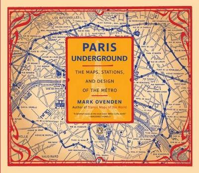
Paris Underground: The Maps, Stations, and Design of the Metro
Paris Underground: The Maps, Stations, and Design of the Metro
[Minkštas viršelis]
4.00/5 (157
ratings by Goodreads
)
Mark Ovenden
Formatas:
Paperback / softback, 176 pages, aukštis x plotis x storis: 278x240x12 mm, weight: 740 g
Išleidimo metai:
01-Oct-2009
Leidėjas:
Penguin USA
ISBN-10:
0143116398
ISBN-13:
9780143116394
Kitos knygos pagal šią temą
:
Travel & holiday guides
- (Šiuo metu turimos knygos:
56 prekės
)
Transport: general interest
- (Šiuo metu turimos knygos:
1 prekės
)
Minkštas viršelis
Kaina:
37,25 €*
* Ši knyga nebeleidžiama, tačiau mes Jums pranešime naudoto egzemplioriaus kainą
Ši knyga nebeleidžiama, tačiau mes Jums pranešime naudoto egzemplioriaus kainą.
Kiekis:
1
2
3
4
5
6
7
8
9
10
Įdėti į krepšelį
Įtraukti į pageidavimų sąrašą
Didesnis paveikslėlis
Formatas:
Paperback / softback, 176 pages, aukštis x plotis x storis: 278x240x12 mm, weight: 740 g
Išleidimo metai:
01-Oct-2009
Leidėjas:
Penguin USA
ISBN-10:
0143116398
ISBN-13:
9780143116394
Kitos knygos pagal šią temą
:
Travel & holiday guides
- (Šiuo metu turimos knygos:
56 prekės
)
Transport: general interest
- (Šiuo metu turimos knygos:
1 prekės
)
Pastovi nuoroda:
https://www.kriso.lt/db/9780143116394.html
Aprašymas
Turinys
Goodreads reviews
More than one thousand maps, diagrams, and photographs offer a graphic history of the Paris subway system.
Introduction RATP President/Guide to the book
4
(2)
Paris prevaricates over a Metro Pre-1900
6
(16)
Birth of a network 1900-1910
22
(14)
The second hand of design 1911-1919
36
(24)
Metro for commerce; unofficial maps 1920-1948
48
(12)
Metro to the city limits 1920-1930
60
(6)
Into the suburbs 1931-1938
66
(10)
War, Occupation and aftermath 1939-1947
76
(8)
RATP to RER 1948-1968
84
(14)
Metro for commerce; unofficial maps 2 1948-1968
92
(6)
A new dawn 1969-1987
98
(10)
The digital era 1988-1999
108
(10)
Palm-size Paris 2000-present
118
(12)
RER: Crossing Paris beneath the Metro 1837-present
130
(12)
Line, in-car and track maps 1900-present
142
(6)
Routes of distortion; the diagram debate 1900-present
148
(18)
Metro for commerce; unofficial maps 3 1969-present
160
(6)
A public face; signage and logos 1900-present
166
(10)
Index, Bibliography
176
Prisijungti
Naujas vartotojas
EST
ENG
LAT
Pagrindinis
Pagalba ir Palaikymas
Kontaktai
Dovanų kuponai*
Paskyra ir nustatymai
Jūsų paskyra
Pirkinių krepšelis
Dovanų kuponai*
Pageidavimų sąrašas
Užsakymų sąrašas
Asmeniniai nustatymai
Keisti duomenis
Pakeisti slaptažodį
Ieškoti
Pirkinių krepšelis
Paieška
Ieškoti duomenų bazėje
Knygos anglų kalba
Knygos anglų kalba
Knygos vokiečių kalba
Knygos rusų kalba
Estiškos knygos
E-knygos anglų kalba
Kalbų mokymo literatūra
Muzikos knygos
Leidyklų e-knygos
Išplėsta paieška
Patikslinti paiešką
Temos
Temos anglų kalba
Arts and Architecture
(1097168)
Biography & True Stories
(840749)
Children's, young adult & educational
(2683363)
Computing & information technology
(412279)
Earth sciences, geography, environment, planning
(290772)
Economics, finance, business & management
(1276443)
English language teaching (ELT)
(59348)
Fiction & related items
(3790729)
Health & personal development
(1432720)
Humanities
(3989567)
Language
(584424)
Law
(677737)
Lifestyle, sport & leisure
(2375738)
Literature & literary studies
(2690528)
Mathematics & science
(837986)
Medicine
(785765)
Reference, information & interdisciplinary subjects
(589829)
Society & social sciences
(2748101)
Technology, engineering, agriculture
(657232)
Paieška potemėse
Ieškoti
Pirkinių krepšelis
Pasirinkti pirkinių krepšelį
Knygos
El. knygos
E-kuponų užsakymai
Eiti į pirkinių krepšelį
Eiti į pirkinių krepšelį
Eiti į pirkinių krepšelį
kriso.ee veikia geriausiai su įjungtu JavaScript.
Apgailestaujame! Jūsų ekrano raiška per maža teisingai atvaizduoti svetainės turinį.
Ignoruoti ir rodyti puslapį